Who Makes the Drone Rules?
Before diving into some of the safe places to fly drones in Charleston, let’s review the fundamental rules for drone operation in the United States. The Federal Aviation Administration (FAA) has legal jurisdiction over all of the navigable airspace in the United States. They have the responsibility to make sure that air traffic operates in a safe and orderly manner. Historically they’ve only accommodated for manned aircraft like airplanes and helicopters. However, with the proliferation of consumer unmanned aircraft (drones), they’ve scrambled to push out new regulations to integrate them into the national airspace.
The first step to integrate drones into the airspace requires them to be registered. The second step is categorizing operators. The FAA arranges drone operators into 4 categories: recreational, commercial, public safety and educational. Each category defines what rules and regulations an operator must follow. The main categories that encompass the majority of operators are recreational and commercial. However, no matter what category an operator falls into, the weight of the drone is what determines if it must be registered with the FAA.
Do I Need to Register My Drone?
In a nutshell, if a drone weighs over .55 pounds (250 grams) the owner must register it with the FAA. The registration requires some basic information such as address, email, phone number and the model and serial number of the drone. The registration costs $5.00 and is valid for 3 years. You can find the registration links at the FAA DroneZone website. If the drone weighs over 55 pounds, the FAA requires a separate registration process located at this link.
Rules for Recreational Drone Operators
Recreational drone operators are defined as those that fly for fun and are not compensated directly or indirectly for their drone content. Examples of non-recreational purposes are when an operator takes photos of a property in order to help sell it, performs a roof inspection, or takes photos of a soccer team to add to their website. If a drone is used to further a business or organization in any way, the FAA considers that to be “non-recreational.”
“Goodwill or other non-monetary value can be considered indirect compensation. This would include things like volunteering to use your drone to survey coastlines on behalf of a non-profit organization. Recreational flight is simply flying for fun or personal enjoyment.” – FAA website
Recreational Drone Operator Rules
-
-
-
- Fly only for fun (recreational purposes)
- Keep your drone within visual line of sight or use a visual observer located next to you who keeps direct communication with the pilot
- Always give way to to manned aircraft. Do not interfere with manned aircraft in any way. (i.e. helicopters, airplanes, jets, etc)
- Get prior authorization when a drone operates in controlled airspace (B, C, D, and E) using LAANC.
- Always fly at 400 feet or below in all airspace. NOTE: Drone flights in certain airspace like near airports, military bases, and government venues are strictly prohibited.
- Take the Recreational UAS Safety Test and carry proof of test passage.
- Register your drone and clearly mark the outside of the drone with the registration number.
- Do not fly over large groups of people or sporting events or over highways or major thoroughfares while congested.
- Do not operate the drone in a dangerous manner or under the influence of drugs and alcohol.
-
-
Rules for Commercial Drone Operators
Commercial drone operators follow the FAA Part 107 guidelines which differentiate from recreational rules. Commercial drone operators certified through the FAA complete a comprehensive knowledge test and an approval process. Upon completion, pilots receive their certification and can legally fly for work or business.
Commercial drone operators have advanced knowledge of airspace operations which grants them privileges that recreational pilots do not have. Night operations, operations from moving vehicles, flight over human beings, and flight in controlled airspace (with authorization) are a few of the privileges that commercial operators use to their advantage. To get started on a Part 107 certification, visit this link at the FAA website.
Safe Places to Fly Drones in Charleston
Finding safe places to fly drones in Charleston is important because it minimizes accidents and keeps it a drone-friendly city. Safety is absolutely the most important rule when a drone is in the air, no matter where the operation is located. So far there have been no major reported drone accidents in the Lowcountry which is fantastic, but don’t be the person who changes that!
The picture below shows the controlled airspace in the Charleston area represented with red circles. The green area all around the red circles is Class G Airspace (up to 1,200 feet) which is uncontrolled airspace. The purple circles are dangerous no fly zones for drones, where aircraft actively takeoff and land. The green area is typically the safest (and legal) place to fly a drone (unless there is a TFR or other known air operations such as helicopter tours). This means an operator can fly a drone recreationally in the green area up to 400 feet, along as the other guidelines are followed.
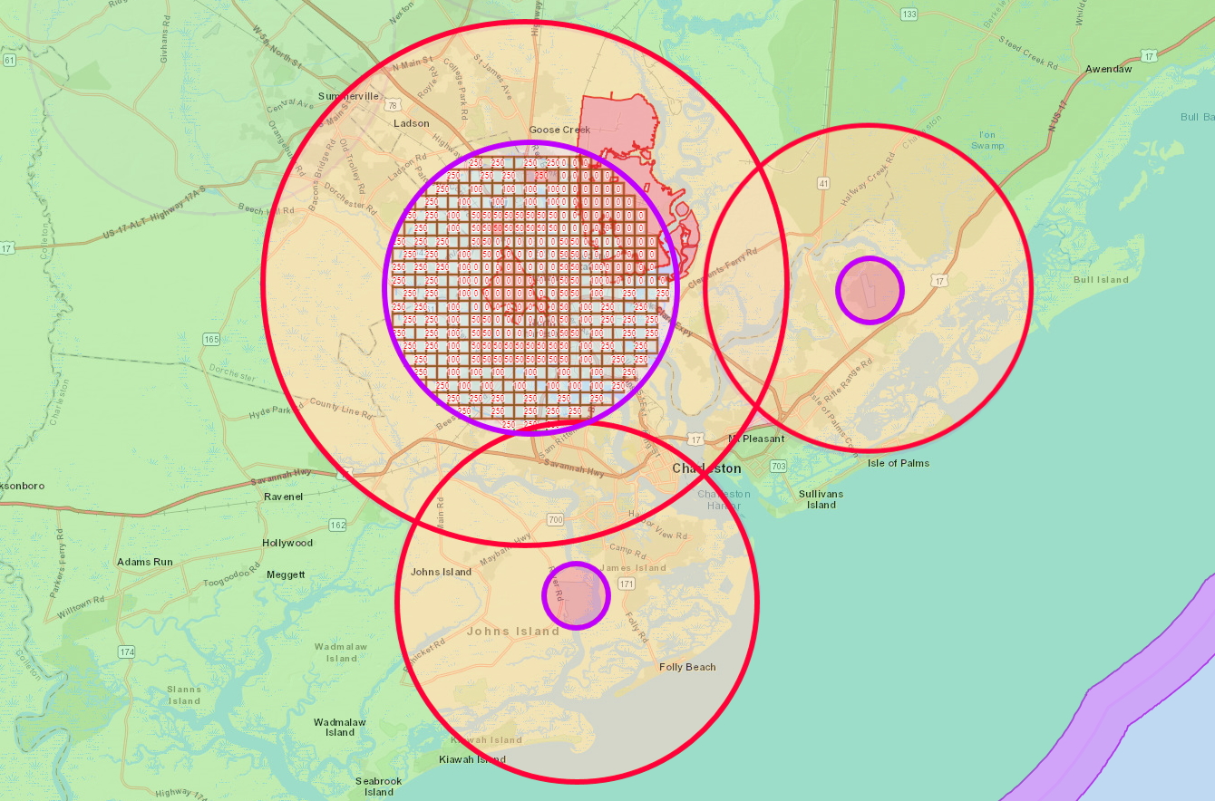
This map is for illustrative purposes only and is not exact. Please research and plan out your flight beforehand.
The yellow area within the red circles represents Class E airspace starting at 700 feet (1,200 feet for Charleston International). A recreational operator can still fly in the yellow areas up to 400 feet, however the buffer between the drone’s upper limit (400 feet) and the manned aircrafts lower limit (700 feet) are within a few hundred feet of each other. Drone pilots should be vigilant of manned aircraft anywhere in the yellow areas. Always avoid other aircraft by giving way to them immediately.
Do Not Fly a Drone Near These Charleston Airports
The red circle located over North Mt. Pleasant in the top right is the airspace for the Mount Pleasant Regional-Faison Field Airport. It’s situated about 1.5 miles north of Highway 17. It’s a public airport primarily for recreational flights. This airport is typically the least busiest of the three airports in Charleston with an average of about 50 flights a day (2019).
Centered between James and Johns Island, towards the bottom of the map, is the airspace for the Charleston Executive Airport. The runways are positioned along the Stono River on the Johns Island side. This airport does not have airliner service, which means it mostly consists of smaller passenger airplanes and general aviation aircraft. It tends to be busier than the Mt. Pleasant airport with an average of 85 flights per day (2019).
However, the largest and most complex airport in Charleston is the Charleston International Airport located in the top left of the picture. It’s located in North Charleston and unlike the other airports, has multiple airspace classes that surround it. The red circle represents Class E airspace starting at 1,200 feet and ending at 4,000 feet. Inside of that airspace is where it turns into Class C airspace within the purple circle. This Class C airspace extends from the surface to 4,000 feet within the purple circle. That means that absolutely no drones or any aircraft can enter that airspace without authorization from air traffic control. This Class C airspace is extremely busy and serves a variety of air traffic which include civil, commercial and military aircraft. On average this airport does 324 flights per day (2019). Avoid drone operations anywhere near Class C airspace or near the Charleston International Airport unless you are absolutely required to and have prior authorization.
Watch Out For Helicopter Tours
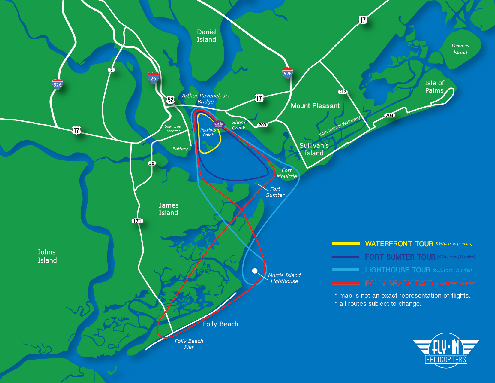
Charleston helicopter routes for “Fly-In Tours” located by the USS Yorktown.
When operators look for safe places to fly drones in Charleston, one thing that is commonly ignored on the pre-flight plan is helicopter routes. Although the airspace in the Charleston harbor is uncontrolled under 700 feet, there is still air traffic that traverses the area at low altitudes. Specifically, FlyIn Helicopters utilizes it for their aerial tours.
The company is located next to the USS Yorktown and offer tour routes that take their clients over the main landmarks around the harbor. Those include Fort Sumter, Morris Island Lighthouse, Folly Beach, Sullivans Island Lighthouse, the Battery downtown, and the South side of the Ravenel Bridge. Their website says tours are offered daily from 10 a.m. – 5 p.m. and tours are weather dependent.
NOTE: In addition to the Fly-In Helicopter tours, there are also 2 helipads located in downtown Charleston at the Medical University of South Carolina and one helipad located in Mt. Pleasant at the East Cooper Medical Center. Although rare, these helicopters are used to airlift the critically wounded to the hospital and should be aggressively avoided at all times. There is no set schedule and no warning for when and where these helicopters will be airborne so be wary around those locations.
Resources to Find Safe Places to Fly a Drone
It’s difficult to find safe places to fly a drone in Charleston or anywhere because there is no central database to find all of the information needed. Therefore, here is a list of digital resources that helps identify areas where it’s safe to fly a drone:
- B4UFLY App – The FAA recommends this app for drone operators. It’s an interactive map that can be downloaded on iOS, Android and is also available for desktop. It displays the basic areas to avoid in a clean interface and allows a user to plan and visualize flights.
- Real Time TFR list – This is a master list of all Temporary Flight Restrictions (TFR’s) in the United States. A TFR can be issued at anytime and anywhere and is meant to halt all air traffic in the area, manned or unmanned. TFR’s are issued when a VIP or government official needs to utilize the airspace. TFR’s can also be issued during an emergency response effort, large sporting event or natural disaster. A good rule of thumb is to check this list at least once to make sure a TFR has not been issued for the area of operation.
- LAANC Authorization – For commercial drone operators (Part 107 holders) who need to fly in controlled airspace, there are now several options to choose for LAANC services. LAANC services allow authorization requests to be processed in almost real time between the FAA, ATC and drone operator.
- VFR Sectional Chart for the region – This chart is a digitized version of the physical copy which is published by the FAA. It is one of the official planning tools used for pilots who operate manned aircraft. If you are not Part 107 certified or have little aeronautical knowledge, the chart maybe difficult to understand. However, this is the most accurate chart to identify what airspace a drone operator can legally use.
- FAA UAS Data Map – This interactive map is watered down version of the sectional chart above and maybe easier to understand and use. It shows recent Temporary Flight Restrictions, offers map layers to display custom airspace types, shows other no-fly zones such as military, national security and special use airspaces.